 |

February 2, 2005 - February 9, 2005
Driving Directions to Murphy and Red Marble
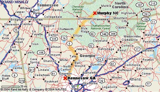
Directions from Atlanta, GA to Murphy, NC
125 Miles, Travel time approximately 2 hours
- Begin on I-75 North
- Exit I-575 North just north of Marietta.
- I-575 becomes Highway 515
- Continue on Highway 515 by-passing the towns of Jasper, Ellijay and Blue Ridge.
- Continue 4 miles North of Blue Ridge.
- Turn Left on Highway 60 and travel approximately 2 miles on this two lane road.
- Turn Right onto Spur 60. This two lane road leads you into Cherokee County where it becomes a four lane road which will intersect with US 64/74.
- Turn Right on US 64/74.
- To go to the funeral home, turn right onto US 64 East and go approximately 4 miles to Cochran Funeral Home on the right.
- To reach Red Marble Church, travel East on US 74 for 18 miles, turn right on the second Red Marble Road. The church will be on the right, about a mile up Red Marble Road.
MAP FROM ATLANTA TO ANDREWS/MURPHY AREA

Directions from Asheville, NC to Cochran Funeral Home
115 miles, Travel time approximately 2 hours
- Follow I-40 (East or West) to exit 27(signs will indicate 74W, to 19, to 23, and to Waynesville)
- Follow US 23 South/74 West towards Waynesville (stay in left two lanes)
- Continue on through the Waynesville exits (you will pass a rest area on your left) and Sylva exits
- Take exit 81 (sign will indicate Dillsboro, Franklin, Atlanta) and follow 23 South (also 441S and 64W)
- Go through stop light in Dillsboro and continue 16 miles to Franklin (you'll pass "Gold City" on right)
- In Franklin you will go through 2 stop lights, but do not leave highway; the road will become US 64 West in Franklin
- Follow US 64 West over the mountains (about 45 miles), pass through the town on Hayesville and continue toward Murphy. On your left, just past Tri-County Community College, is Cochran Funeral Home.
Directions from Asheville, NC to Red Marble Baptist Church
105 Miles, Travel time approximately 2 hours
- Begin I-40 West
- Continue on I-40 to Exit 27.
- Take Exit 27. This exit is easy to miss. Exit sign reads "Franklin, Murphy, Atlanta."
- Proceed on US 74 West, by-passing the towns of Waynesville, Cherokee, Sylva and Bryson City. The four lane then becomes two lane US 19/74 West as you approach the Nantahala Gorge. You will travel about 15 miles before entering Cherokee County at Topton.
- After passing the Post Office, on your right, in Topton (the Post Office IS Topton!), begin looking for Red Marble Road on your left. Turn onto Red Marble Road and come to the Red Marble Baptist Church, which is in the right.


Site designed and developed by Pamela Carman

|